Discover the Excitement of Geography with Our U.S. Map Puzzle
- Fun House Toys

- Nov 16, 2025
- 5 min read
A Sustainable Learning Experience
Unlike our previous printable crafts, this model is part of our new Learning Collection. It is made from sustainable, non-toxic PLA material. These models are durable, display-ready, and perfect for homeschool, classroom settings, or weekend science fun at home.
And yes—while this version is a ready-to-go physical product available in our shop, we still include a free black-and-white worksheet version at the end of this post. This allows your little learners to color, cut, and label on paper too!
🧠 Why Hands-On Geography Works
Children remember more when they do the learning rather than just seeing it. By picking up each state piece, placing it on the board, and noticing its shape and neighbors, kids build strong connections that help them remember:
State names
U.S. regions
Borders and coastlines
Geography terms like “Great Lakes,” “Gulf Coast,” and “New England”
The puzzle brings geography to life and introduces kids to a big world in a way that feels playful and manageable.

ADVERTISMENT
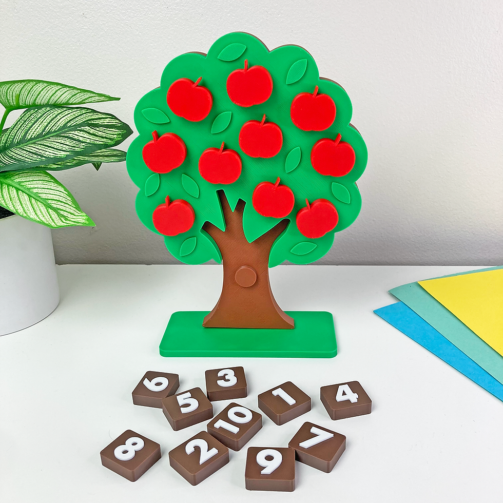
We have a shortlist of favorite science crafts like Layers of Atmosphere, Inner Earth Layers, Anatomy of a Volcano, and Layer of the Ocean. This activity is sure to become a new favorite. It comes together quickly and is packed with educational insight.
It’s beneficial for:
Visual learners who love building and seeing how things fit together.
Kids studying earth science, human body, or life science.
Homeschoolers and teachers needing hands-on activities for science units.
Gifted kids who enjoy tactile puzzles with an educational twist.
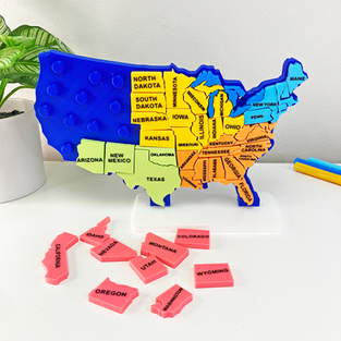
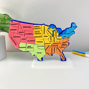
🧩 About the Puzzle
Our U.S. Map Puzzle includes 54 total pieces, featuring:
47 individual state pieces (Connecticut & Rhode Island are combined for safe, durable play)
The Great Lakes
A coastal island piece near Virginia
A sturdy base stand for display
🌟 How to Use Your U.S. Map Puzzle
Here are some tried-and-true activities to help kids stay engaged and excited while they learn:
1. Build the Map Without a Guide
Challenge your child to complete the puzzle without looking at the labeled printable. You’ll be surprised how quickly they start recognizing shapes like Florida, Texas, and Michigan!
2. Region Sorting Game
Group states by region before placing them:
Northeast
West
Midwest
Southwest
Southeast
This helps kids understand how states fit into larger parts of the country.


ADVERTISMENT
3. “Find the State!” Speed Challenge
Call out a state name or show it on the printable. Your child chooses the matching piece and places it on the map. Perfect for kids who love fast-paced challenges!
4. Great Lakes Explorer
Place the Great Lakes pieces and talk about how they connect to different states. Kids are always amazed that lakes can be that big!
5. State Facts Scavenger Hunt
Pick a state and search for:
Its capital
A famous food
A fun landmark
A famous person from that state
Kids can write their findings on the printable sheet.
6. Puzzle Display Time
When the map is finished, stand it up with the included base and create a learning corner. Kids love seeing their work displayed—and it encourages repeat play.
ADVERTISMENT
❓ Guided Questions to Ask During the Activity
These simple questions help kids think deeper, make connections, and talk through what they see:
“Which state piece feels the biggest? Which feels the smallest?”
“Can you find a state that touches the ocean?”
“Which states have straight lines for borders? Why do you think that is?”
“What states look like they fit together like puzzle buddies?”
“Can you find a state that touches more than one Great Lake?”
“Which state would you want to visit first? What would you want to see there?”
“Do you notice groups of states that look similar or stay close together?”
“Can you find a state that is shaped like something familiar — an animal, a boot, a mitten?” (Kids LOVE this one.)
“If you drove from one corner of the country to the other, which states would you pass through?”
These questions help build observation skills, geography knowledge, and critical thinking — while keeping the activity fun.
ADVERTISMENT
🌎 Real-World Comparisons Kids Can Understand
Help kids picture the U.S. map using things they already know:
“Texas is almost as big as France!”
“You could fit all of New England inside Montana — and still have room!”
“California’s coastline is longer than the distance from New York to Florida.”
“The Great Lakes are so big they look like oceans — you can’t see across them!”
“Alaska is bigger than Texas, California, AND Montana put together.”
“Hawaii is made of islands — like stepping stones in the ocean.”
“Florida sticks out like a giant thumb pointing into the ocean.”
“Michigan looks like a mitten — some people call it ‘The Mitten State.’”
Real-world comparisons make geography feel familiar and easy to remember.
⭐ Fun Facts to Spark Curiosity
Kids love little surprises, and these facts get them excited to learn more:
Alaska has more coastline than all the other states combined.
Rhode Island is the smallest state — you could fit it into Texas over 200 times!
The Great Lakes hold about 20% of the world’s fresh water.
Arizona is the sunniest state in the U.S.—perfect for spotting desert landscapes.
The Mississippi River flows through or touches 10 different states.
Hawaii is the only state that grows coffee commercially.
Maine is the U.S. state closest to Africa.
North Carolina was the home of the first airplane flight — the Wright Brothers flew there!
Sprinkling fun facts into your activity makes kids excited to keep exploring and discovering the country piece by piece.

ADVERTISMENT
✋ Why Hands-On Learning Matters
Studies show that children retain more information when they can see and touch what they’re learning. Our science kits support:
Montessori-style learning through tactile exploration.
Waldorf-inspired creativity using color, texture, and storytelling.
STEM education with real-life applications and vocabulary.
Life science curriculum goals for grades K–5.
Try These Science Activities
All of these crafts can be made with no prep to make your activity planning even easier!
Layers of Atmosphere - Layers of the Earth Space.
Inner Earth Layers - Layers of the Earth Inner Core.
Anatomy of a Volcano - Explore volcanoes in a fun and educational way.
Milky Way Spiral - Journey through our Galaxy.
ADVERTISMENT
♻️ Built for the Planet and Built to Last
All of our 3D science models are crafted using PLA, a material derived from plants like corn. This means they are:
Non-toxic
Biodegradable
Safe for kids
Eco-friendly
Just like every item in our shop, this is designed, hand-drawn, and printed by our family-owned team right here in Georgia, USA. We love creating tools that make science more accessible and fun!


Not ready to commit to the 3D version just yet? We’ve got you covered! Click on the printer icon to download a FREE black-and-white worksheet version. It’s perfect for coloring, cutting, and reviewing through paper-based fun.
Our goal is to make space learning exciting, engaging, and hands-on. With this interactive learning toy, your child can build, learn, and imagine.
Love this printable?
Join our community on social media and be the first to discover exciting new activities, exclusive freebies, and limited-time discounts. Follow us, and let’s make learning even more fun and creative together!